Description

DOCUMENTING AN OUTDOOR STUDIO PRACTICE: CREATED BY SUSAN CAMPBELL

Tuesday 27 September 2011

Studio #4

By continuing to work in and through the site, I am attempting to resolve the following issues:
  • the degree to which visual culture increasingly attributes a dollar value to trees, both in terms of their energy savings as an environmental resource, and their asset value as a natural resource;
  • perceived tensions around dimensionality: between two-dimensional mapped space and three-dimensional situated space;
  • the map's remit is to both literally, and sometimes figuratively, flatten my world. My installation reconfigures both the material and visual language that pertain to the site, as an attempt to deconstruct the objectivity of mapping practices;

    Fabricating and stamping asset tags with sequential numerals.
    A mature tree provides $162,000 in ecological goods and services over a 50 yrs.

    LEAF - Local Enhancement & Appreciation of Forests along with five other groups around the province held events to officially launch the newly created Urban Forest Stewardship Network (UFSN) and its website, www.ufsn.ca. The network is designed to facilitate an exchange of ideas, resources and contacts for those community groups and individuals in Ontario interested in improving their local urban forest.

      Thursday 15 September 2011

      Studio #3

      It became more resolved for me to somehow draw into rather than draw out from this place, particularly since the contents of the site were now largely absent. The lack of a focal point became part of the reason I wanted to work within this site. This chunk of natural woodland, previously protected for its conservation value was now encroaching on the unique selling point (referred to as USP) of the Toronto Brickworks. In order to improve visibility of the brickworks from the Belt Line Trail, a plan was devised to cut through a wide expanse of the woodland where a path already existed.


      A few trees were designated to stay along the perimeter of the site, all metal-tagged in sequential order. Looking at the site, I sensed this ever growing tension between what exists here and what is shown to exist virtually on the map. I imagined the map's grid pattern acting as a giant filter, calibrating the grand scheme of things: orange line represents highway; blue dotted line for bicycle path, and Pantone Green 360 for woodland. But suppose one was commissioned to produce a map of the entire Don Valley area, from Highway 401 down to The Lakeshore: would this now absent woodland continue to be referenced using Pantone Green 360? At what point does the cartographer notice that this stretch of now absent woodland is extensive enough to warrant inclusion in the map?

      Wednesday 14 September 2011

      Studio #2

      I returned to the deforested site to consider the ways in which I could document this transposition. My approach was one of blindly feeling my way tentatively across this field of bark and broken sticks. Walking slowly on the unfamiliar ground, I began to get a sense of the rearrangement between Man and nature. Bumping gently into a tree, I used it for support as I knelt down to pick up some branches, wedging them into position between the first and second tree, an effort, no doubt, to find some purpose to this authorised desolation.


      As already mentioned, I was struck by the contrast between how rarified the old brick became and the disposability of the now absent trees, so I decided to perform as an archaeologist would in order to investigate the possibilities of the site further. As well as making graphite drawings, I excavated one or two areas, careful not to disturb the soil surrounding the brick. I cleared away, dug around, and swept back the soil and foliage covering the brick fragments.


      Sunday 11 September 2011

      Studio #1

      My artistic practice investigates the tensions between physical boundaries (space as it is experienced) and virtual boundaries (space as it is represented). Mapping traditionally conveys a stable relation between physical territory and occupation of that space. More recently however, mapping practices – actions and performances – have tended to undermine the impression of stability.

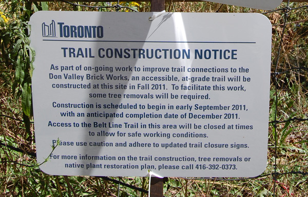
      A particular instance of this kind of tension became apparent on one of my recent excursions: We all know that the green hue on a map generally indicates a forested area or parkland, while purple or pink often indicate an urban or commercial district. Additionally, the map is an effective instrument for demarcating what's public and what's private, what's open, what's closed, what's conserved, what's not. Now imagine my confusion when I was standing in a field of bark where all the trees had suddenly vanished. What surprised me most about this scene was the thoroughness with which every kind of species had been removed, leaving no trace of trunk, bow or branch. A little unusual for conservation parkland I thought, particularly in light of the general rule-of-thumb that says: when a tree falls, leave it there to settle back into the earth. Walking through the aftermath, I couldn't help but notice all the leftovers of old brick, sticking up out of the ground like remnants of some bygone era; the Toronto Brickworks had once produced brick for most of Toronto and the surrounding area. This acre or so of land is situated in the Don Valley, along the Belt Line Trail just behind the restored warehouses of Toronto Brickworks, now a popular heritage attraction.


      To my mind, a curious transposition had taken place between the leftover bricks and the now absent trees: these bricks may originally have been cast-offs but now they appeared as valued remnants, while the trees, once protected, were now disposable. I wanted to document this transposition and make it more visually apparent by adopting the following criteria:
      • DRAWING to signify:
        remnant of a forgotten past, emblem of a lost craft, fragment of hand-crafted building material, protected and rarified artefact, requiring many man-hours to become;
      • FABRICATION to signify:
        quality-controlled production, cost-effective practice, labour-saving method, countless copies, widely available commodity.
      For the installation, I wanted the bark to appear as if it had been fabricated, and the brick to appear as if it had been discovered.